Flying Saucer - Like Clouds: Lenticular Clouds
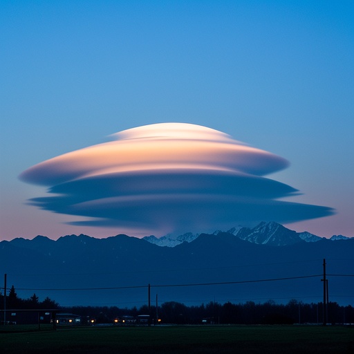 Yes, there is a type of cloud that looks remarkably like a flying saucer, known as a lenticular cloud. Lenticular clouds are stationary lens - shaped clouds that form in the troposphere, usually in areas with stable air and strong winds. The troposphere is the lowest layer of Earth's atmosphere, where most of our weather occurs. Stable air is crucial for the formation of lenticular clouds because it allows the air to maintain a certain pattern as it moves over geographical features. Strong winds, on the other hand, provide the necessary force to push the air up and over obstacles like mountains.
Imagine standing on a clear day, looking up at the sky, and suddenly spotting a strange, circular object hovering in the distance. Your first thought might be that it's a UFO. But more often than not, what you're actually seeing is a lenticular cloud. These clouds have a way of captivating our attention with their otherworldly appearance. They seem to defy the normal rules of cloud movement, remaining stationary in the sky while other clouds drift by. This stationary nature adds to their mystery and makes them even more likely to be mistaken for something extraterrestrial.
 The formation of lenticular clouds is closely related to the flow of air over mountains. When moist, stable air is forced to rise over a mountain range, it cools as it ascends. This cooling process is a fundamental principle of meteorology. As air rises, it expands due to the decrease in atmospheric pressure. This expansion causes the air to cool, and when it reaches its dew point, water vapor begins to condense. The dew point is the temperature at which the air becomes saturated with water vapor, and condensation occurs.
Let's take a more detailed look at this process. Picture a large mass of moist air approaching a mountain range. As the air encounters the mountain, it has nowhere to go but up. The mountain acts as a barrier, forcing the air to change its direction and start climbing. As it ascends, the air temperature drops steadily. For every 1000 meters of ascent, the air temperature typically decreases by about 6.5 degrees Celsius. This significant drop in temperature is what triggers the condensation of water vapor.
However, unlike normal clouds that are carried along by the wind, the air in a lenticular cloud situation forms a standing wave pattern. The air rises on the windward side of the mountain, reaches its condensation point to form a cloud, and then descends on the leeward side. As it descends, the air warms and the cloud evaporates. But the wave pattern continues downstream, and new clouds form at the crests of these standing waves. These standing waves are similar to the waves you might see in a river when the water flows over a rock. The water forms a series of waves that seem to stay in one place, even though the water is constantly moving. In the case of lenticular clouds, the air is moving over the mountain, creating these standing wave patterns in the atmosphere.
There are different types of standing waves that can lead to the formation of lenticular clouds. One common type is the mountain wave. Mountain waves occur when the air flow is perpendicular to the mountain range. The shape and height of the mountain, as well as the strength and direction of the wind, all play a role in determining the characteristics of the mountain wave. Another type is the lee wave, which forms on the leeward side of the mountain. Lee waves can extend for long distances downstream and can result in the formation of multiple lenticular clouds.
 This process results in the distinctive, saucer - like shape of lenticular clouds. They often have a smooth, rounded appearance, with a well - defined edge, which makes them look very much like the classic image of a flying saucer. The smoothness of their shape is due to the laminar flow of the air within the cloud. Laminar flow means that the air moves in parallel layers, without much turbulence. This allows the cloud to maintain its shape and gives it that characteristic flying - saucer look.
The well - defined edge of lenticular clouds is also a result of the balance between condensation and evaporation. As the air rises and cools, condensation occurs at the leading edge of the cloud. At the same time, as the air descends and warms on the other side, evaporation takes place. This continuous cycle of condensation and evaporation keeps the cloud's edge sharp and distinct. It's almost as if there is an invisible boundary separating the cloud from the surrounding air.
Due to their unusual shape and often bright colors caused by the way sunlight interacts with the water droplets in the cloud, lenticular clouds are frequently mistaken for UFOs. When sunlight passes through the water droplets in the cloud, it undergoes a process called refraction. Refraction is the bending of light as it passes from one medium to another. In this case, the light is passing from the air into the water droplets and then back into the air. This bending of light can cause the cloud to appear in a variety of colors, including shades of orange, pink, and purple. These vivid colors, combined with the cloud's strange shape, make it a truly captivating sight.
In fact, many reported UFO sightings can be traced back to the presence of these fascinating natural phenomena. Throughout history, there have been numerous accounts of people claiming to have seen UFOs, only to later discover that what they actually saw was a lenticular cloud. For example, in some small towns, a sudden appearance of a lenticular cloud in the sky has caused panic among the residents. People have reported seeing strange lights and objects hovering in the air, and it wasn't until meteorologists explained the phenomenon that the fear subsided.
The unique formation mechanism and eye - catching appearance make lenticular clouds one of the most interesting cloud types in the sky. They serve as a reminder of the beauty and complexity of nature. Studying lenticular clouds can also provide valuable insights into the behavior of the atmosphere. Meteorologists use data from lenticular cloud formations to better understand air flow patterns, temperature changes, and moisture distribution in the troposphere. By analyzing these clouds, they can improve weather forecasting models and gain a deeper understanding of how our atmosphere works.
Moreover, lenticular clouds can have an impact on aviation. Pilots need to be aware of their presence because the strong winds and turbulence associated with the standing wave patterns can pose challenges to flight safety. The sudden changes in air pressure and wind speed near lenticular clouds can cause the aircraft to experience rough air and unexpected jolts. Pilots often use weather radar and other instruments to detect the presence of lenticular clouds and adjust their flight paths accordingly.
In conclusion, lenticular clouds are a remarkable natural phenomenon. Their resemblance to flying saucers has captured the imagination of people around the world, and their formation process is a fascinating example of the complex interactions between air, water, and geographical features. Whether you're a weather enthusiast, a pilot, or just someone who enjoys looking up at the sky, lenticular clouds are definitely worth taking the time to observe and appreciate.